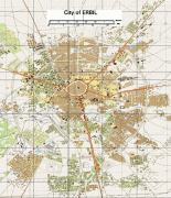
Erbil (Erbil)
Human settlement at Erbil may be dated back to the fifth millennium BC. At the heart of the city is the ancient Citadel of Erbil and Mudhafaria Minaret. The earliest historical reference to the region dates to the Third Dynasty of Ur of Sumer, when King Shulgi mentioned the city of Urbilum. The city was later conquered by the Assyrians.
In the 3rd millennium BC Erbil was an independent power in its area. It was conquered for a time by the Gutians. Beginning in the late 2nd millennium BC it came under Assyrian control. Subsequent to this, it was part of the geopolitical province of Assyria under several empires in turn, including the Median Empire, the Achaemenid Empire (Achaemenid Assyria), Macedonian Empire, Seleucid Empire, Armenian Empire, Parthian Empire, Roman Assyria and Sasanian Empire, as well as being the capital of the tributary state of Adiabene between the mid-second century BC and early second century AD. In ancient times the patron deity of the city was Ishtar of Arbela.
Following the Muslim conquest of Persia, it no longer remained a unitary region, and during the Middle Ages, the city came to be ruled by the Seljuk and Ottoman empires.
Erbil's archaeological museum houses a large collection of pre-Islamic artefacts, particularly the art of Mesopotamia, and is a centre for archaeological projects in the area. The city was designated as Arab Tourism Capital 2014 by the Arab Council of Tourism. In July 2014, the Citadel of Erbil was inscribed as a World Heritage Site.
The city's ancient name, known in the classical era as Arbela (Greek: Ἄρβηλα; translit. Arbēla), can be traced back to Old Persian Arbairā and ultimately Assyrian Arbailu.
Map - Erbil (Erbil)
Map


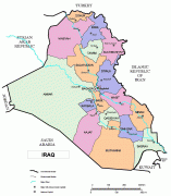


Country - Mesopotamia
 |
|
| Flag of Iraq | |
The Sumerians and Akkadians (including Assyrians and Babylonians) originating from different areas in present-day Iraq, dominated Mesopotamia from the beginning of written history (c. 3100 BC) to the fall of Babylon in 539 BC, when it was conquered by the Achaemenid Empire. It fell to Alexander the Great in 332 BC, and after his death, it became part of the Greek Seleucid Empire. Later the Arameans dominated major parts of Mesopotamia (c. 900 BC – 270 AD).
Currency / Language
| ISO | Currency | Symbol | Significant figures |
|---|---|---|---|
| IQD | Iraqi dinar | عد | 3 |
| ISO | Language |
|---|---|
| AR | Arabic language |
| HY | Armenian language |
| KU | Kurdish language |